
Sedalia/Warrensburg Area Included in Possibility of Flash Flooding
In Sedalia and the surrounding area, we're not in the line of the watch for the flash flooding but as you travel further west, our friends and neighbors are more likely to see the results of this system moving through the area.
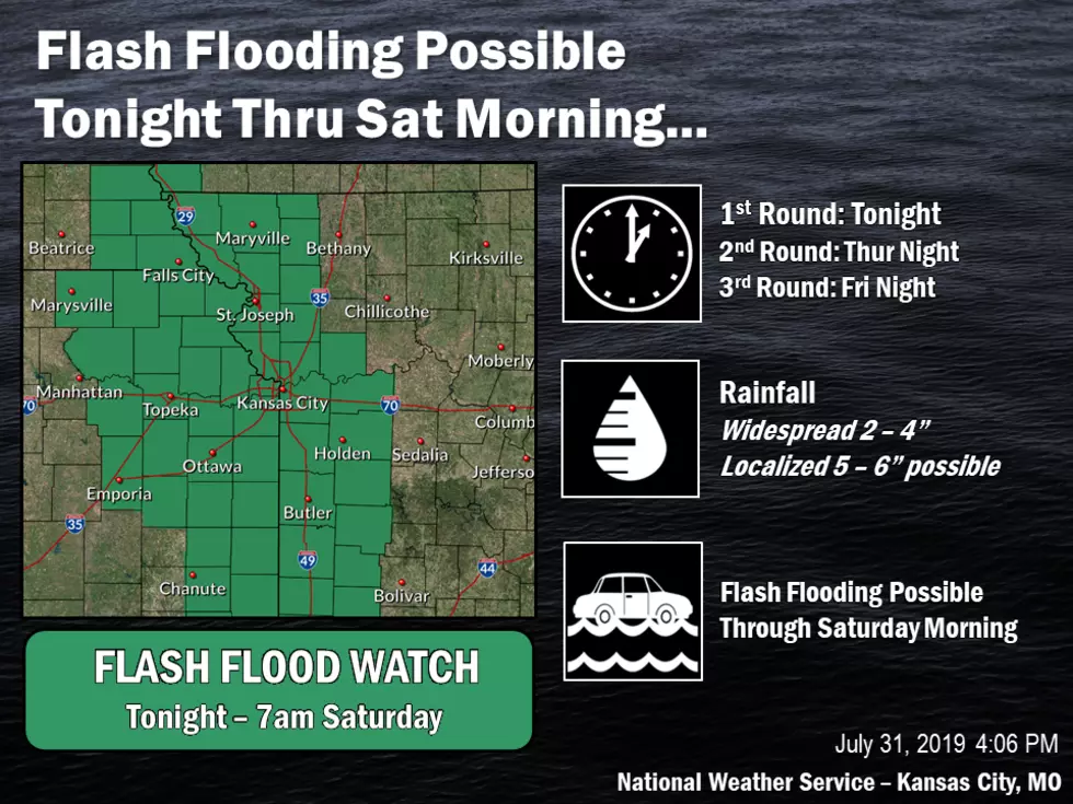
Multiple rounds of thunderstorms producing heavy will continue through Saturday morning. Widespread rainfall amounts of 2 to 4 inches are expected with locally higher amounts up to 6 inches possible. Each round of heavy rain will increase the threat for flash flooding concerns, thus a Flash Flood Watch has been issued and will be in effect from late tonight through Saturday morning.
Here's the forecast through the weekend for Sedalia according to the National Weather Service:
TodayA slight chance of showers and thunderstorms after 7am. Cloudy, then gradually becoming mostly sunny, with a high near 82. East wind 5 to 7 mph. Chance of precipitation is 20%.TonightA slight chance of showers and thunderstorms. Partly cloudy, with a low around 64. East wind 6 to 8 mph. Chance of precipitation is 20%.FridayA chance of showers and thunderstorms, mainly after 8am. Sunny through mid morning, then becoming cloudy, with a high near 78. East wind 6 to 9 mph. Chance of precipitation is 40%. New rainfall amounts between a quarter and half of an inch possible.Friday NightA chance of showers and thunderstorms. Mostly cloudy, with a low around 65. East wind around 6 mph becoming calm in the evening. Chance of precipitation is 40%. New rainfall amounts between a quarter and half of an inch possible.SaturdayA chance of showers and thunderstorms, mainly before 2pm. Partly sunny, with a high near 81. Calm wind becoming southeast around 6 mph in the afternoon. Chance of precipitation is 40%. New rainfall amounts between a quarter and half of an inch possible.Saturday NightA slight chance of showers and thunderstorms before 8pm. Mostly clear, with a low around 63. Chance of precipitation is 20%.SundaySunny, with a high near 83.

More From Mix 92.3


