Spring-like Weather and Then Back to Possibility of Snow
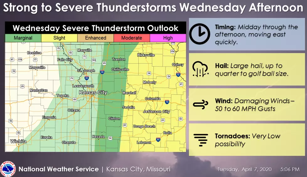
Strong to severe thunderstorms are expected across portions of Missouri Wednesday Afternoon. Storms are expected to quickly move to the east through the late afternoon and evening, with damaging hail being the primary concern.
Here's the forecast for the Sedalia/Whiteman AFB/Warrensburg area according to the National Weather Service:
TodayA slight chance of showers after 5pm. Sunny, with a high near 85. Light and variable wind becoming west 8 to 13 mph in the morning. Winds could gust as high as 21 mph. Chance of precipitation is 10%.TonightMostly clear, with a low around 40. Breezy, with a north wind 16 to 21 mph decreasing to 7 to 12 mph after midnight. Winds could gust as high as 34 mph.ThursdaySunny, with a high near 56. Northwest wind 8 to 18 mph, with gusts as high as 26 mph.Thursday NightMostly clear, with a low around 30. Northwest wind 5 to 9 mph becoming light north after midnight.FridaySunny, with a high near 55. Calm wind becoming southwest around 5 mph in the afternoon.Friday NightA chance of showers after 1am. Mostly cloudy, with a low around 43. Chance of precipitation is 30%. New precipitation amounts of less than a tenth of an inch possible.SaturdayA chance of showers. Mostly cloudy, with a high near 61. Chance of precipitation is 40%.Saturday NightShowers likely, mainly after 1am. Mostly cloudy, with a low around 48. Chance of precipitation is 60%.SundayShowers likely, with thunderstorms also possible after 1pm. Mostly cloudy, with a high near 59. Chance of precipitation is 60%.Sunday NightA chance of showers before 1am. Mostly cloudy, with a low around 33. Chance of precipitation is 30%.MondayA chance of rain and snow showers. Partly sunny, with a high near 47. Chance of precipitation is 30%.Monday NightMostly cloudy, with a low around 31.TuesdayA chance of rain and snow showers. Mostly sunny, with a high near 48. Chance of precipitation is 30%.

More From Mix 92.3